Trail Walking La Ferrière-Béchet - La Ferrière Béchet (Boucle) - Photo

La Ferrière Béchet (Boucle)

 neitag61
neitag61

User

© OpenStreetMap contributors
Length
Length
13.2 km
Max alt
Max alt
340 m
Uphill gradient
Uphill gradient
243 m
Km-Effort
Km-Effort  
16.4 km
Min alt
Min alt
193 m
Downhill gradient
Downhill gradient
242 m
Boucle
Boucle
Yes
Creation date :
2016-04-15 00:00:00.0
Updated on :
2016-04-15 00:00:00.0

(0 Reviews)

Walking
Walking
3h00
Difficulty : Easy

Scan this QR Code to open this trail in the SityTrail application

FREE GPS app for hiking

Logo SityTrail SityTrail

IGN / Geographical institutes

Download SityTrail from the App Store Download SityTrail from Google Play

Logo SityTrail SityTrail World

The world is yours!

Download SityTrail from the App Store Download SityTrail from Google Play Download SityTrail on Huawei AppGallery

About

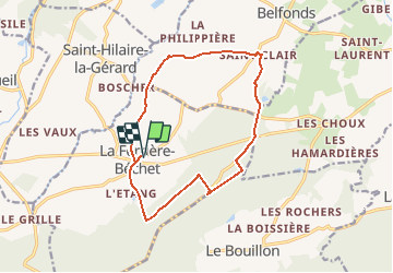
Trail Walking of 13.2 km to be discovered at Normandy, Orne, La Ferrière-Béchet. This trail is proposed by neitag61.

Description

Départ Eglise de la Ferrière Bechet
Circuit de 13 Km dont 9.5 Km de chemin
( circuit pour cavaliers également )

Elevation profile

Points of interest

Point of interest Belfonds - Panorama - Photo
neitag61
BELFONDS 
Point of interest La Ferrière-Béchet - Magnifique Panorama au Nord Oues - Photo
neitag61
LA FERRIÈRE-BÉCHET 

Positioning

Country:
France
Region :
Normandy
Department/Province :
Orne
Municipality :
La Ferrière-Béchet
Location:
Unknown
Start:(UTM)
284153 ; 5385008 (31U) N.

Trails nearby

Trail Walking La Ferrière-Béchet - Forêt d'Ecouves - Photo
Walking
PatRando

Walking

Medium
La Ferrière-Béchet, Normandy, Orne, France
10 km | 12.9 km-effort
1h 46min
Yes
Trail On foot La Ferrière-Béchet - La Forêt d'Ecouves - Photo
On foot
PRO

On foot

Easy
La Ferrière-Béchet, Normandy, Orne, France
8.1 km | 10.4 km-effort
2h 21min
No
Trail Walking Le Bouillon - Alençon : La Forêt d'Écouves  - Photo
Walking
tracegps

Walking

Medium
Le Bouillon, Normandy, Orne, France
13.5 km | 17.5 km-effort
3h 30min
Yes
Trail Walking Le Cercueil - Le Cercueil  - Photo
Walking
jpblimond

Walking

Easy
Le Cercueil, Normandy, Orne, France
12.3 km | 15.1 km-effort
3h 14min
Yes
Trail Walking Mortrée - St Hilaire la Gerard - Photo
Walking
HUBERTClaude

Walking

Difficult
Mortrée, Normandy, Orne, France
11.3 km | 13.2 km-effort
2h 31min
Yes
Trail Walking Le Bouillon - point culminant de la Normandie  - Photo
Walking
yvesportier

Walking

Easy
Le Bouillon, Normandy, Orne, France
4.2 km | 5.1 km-effort
57min
Yes
Trail Car Saint-Gervais-du-Perron - 2019-11 Ecouves VduP - Photo
Car
patrick2m

Car

Saint-Gervais-du-Perron, Normandy, Orne, France
27 km | 33 km-effort
3h 13min
No
Trail Car Le Bouillon - 2019-10-23 Ecouves V du P - Photo
Car
patrick2m

Car

Le Bouillon, Normandy, Orne, France
42 km | 53 km-effort
4h 41min
Yes
Trail Walking Le Bouillon - Forêt d'Écouves 121019 - Photo
Walking
bgsegaud

Walking

Easy
(1)
Le Bouillon, Normandy, Orne, France
12.7 km | 15.3 km-effort
5h 22min
No


Close
My subscriptions